27 October 2016. Thursday.
The Nest at Namche.
Namche Bazaar, Khumbu, Nepal. 3,440m asl.
My headache was gone by early evening when I woke up after a three-hour siesta. Earlier in the afternoon, I took a hot shower and an Advil to relieve the nagging headache that started soon after lunch. In Phakding, the price for the hot shower was still low at 250 Nepalese Rupees (around PhP 120). On the trail, hot showers came at a price directly proportional to altitude; the higher the altitude the higher the cost of hot shower. I planned to take as much hot showers as I could before the prices got unreasonably high and while I could still stand the cold.

- Lifesavers on the trail. Aquatabs from YVR (Thanks, Boss!)
So about hygiene on the trail. Since conception of my trek, I conditioned myself to the substandard sanitation of rural Nepal. I even planned to get hepatitis and typhoid shots a couple of months before flying to Nepal. I didn’t get any, though. I just promised myself I would be extra cautious of the food and water I’d take in, bought a water-purifying bottle and two boxes of Aquatabs. A sick tummy was the second-last thing I would want to contract on the EBC trail, the last one, of course, was altitude sickness.
So far, the most cultural thing (hygiene-wise) I encountered on the trail were the pit latrines. It’s like a Portalet but in place of high quality plastic, the pit latrine’s shelter was made of wood. Also, there’s no toilet, just a hole on the wooden floor no larger than a dinner plate. Underneath the shelter was a pit where human wastes were collected—no need to flush because everything went straight to the pit. Very convenient.

See the drop hole? Pit latrines in Nepal have dried leaves, I guess, to eliminate odor.
It was one of my early struggles on the trail. I had a hard time aiming for and keeping my balance on top of that drop hole every time I relieved myself. This was even made more uncomfortable by the cold air brushing past my bare, uhm, gems.
Meanwhile, sanitation in teahouses had improved greatly over the years. If what I had been seeing was subpar, I didn’t want to think what it’s like 20 or 30 years ago. It was a relief that our teahouse had quite a number of sinks with faucet, free-flowing freezing water and hand soap. There were two western-type toilets with flush for every floor of the two-story teahouse but the shower room was located outside the main building. One would have to cross the main EBC trail to take a hot shower.
Of course, there’s also the issue of annoying unhygienic trekkers I had to share these toilets and baths with. Although teahouse staff maintained cleanliness in all areas especially the bathrooms, some trekkers can be inconsiderate to other trekkers who may not be used to such filth. I could not stress how thankful I was to discover a travel size Lysol disinfectant spray in the Philippines. It’s a lifesaver. That and wet wipes and alcohol.
So, on with the trek. Today, we’re bound for Namche Bazaar, the largest Sherpa settlement in the region and also known as the Gateway to Everest. It’s a six- to seven-hour walk from Phakding with an elevation gain of about 790 meters. We left the teahouse at around 7:30 am to reach the village of Jorsale by 11am. Today’s trek was divided in two—the easy breezy Phakding-Jorsale leg and the dreaded ascent to Namche Hill before slightly descending to Namche Bazaar. Jangbu warned this was the hardest part of the trail because of the high pass we needed to go through.

Morning view

Baguio feels ❤
The route to Jorsale was relatively easy, for the legs and on the eyes; it was almost level with occasional steep ascents and some beautiful waterfalls and riverscapes along the way. We arrived in Jorsale about a quarter to 11 am and covered a distance of 9.65 kilometers in about 3 hours and 10 minutes. Turtle pace.
Soon after lunch in Jorsale, we left for Namche, another 3-4 hours of walking and hiking up to Namche Hill. But before the vicious climb, we first checked in at the entrance of Sagarmatha National Park, the official name of the area encompassing the trail from Jorsale up to the summit of Mt. Everest, sharing the international border with Chomolungma Nature Preserve of Tibet. Everest is known among the Nepalese as Sagarmatha (Goddess of the Sky) while in Tibet she is known as Chomolungma or Goddess of the Universe. The name, Everest, on the other hand, was given by the Surveyor General of India, Andrew Waugh, in honor of his predecessor, George Everest. It was Waugh who first spotted this massive goddess in the 1840s.

Unnamed waterfall on the way to Jorsale.

Trekkers must register here at the entrance of Sagarmatha National Park.
One of the many sacred mountains of the Sherpa people, Khumbila, welcoming us to Everest region.
And this was it. We’re officially entering Everest territory.
Next to getting warm and cozy inside our teahouse, crossing the Hillary suspension bridge was my most awaited moment today. Every documentary and movie I saw about Mt Everest featured a shot of this bridge and I intended to document my own historic crossing of this hanging bridge. Why it was famous, I couldn’t tell. Maybe because it was the only suspension bridge with a name. Or maybe because it was the most picturesque of all hanging bridges with its cable ropes swathed by new and faded prayer flags constantly fluttering in the wind. It didn’t matter. I have always been drawn to and charmed by bridges and what it represents and that’s enough reason for me to be so eager about crossing Nepal’s suspension bridges.

One of the five suspension bridges we crossed on Day 02 of trekking.
The Hillary Suspension Bridge was the last of the five bridges we crossed today and it led us to Namche Hill, the gruesome high pass we needed to go through to get to the village of Namche Bazaar.


First we needed to hike up to Hillary Suspension Bridge to get to the opposite side of the Dudh Kosi, then continued hiking Namche Hill.
Inhale with your mouth slightly open, just like when you’re running. You can stop when you feel tired. This was my mantra, reciting it as I huffed and puffed my way up to 3,400m. Our small group sort-of merged with a Norwegian couple and their guide as we ascended the hill, stopping every 5 or 10 minutes to catch our breaths and making sure we all maintained a slow pace so as not to overexert ourselves.

Wildlife by the trail!

See, it’s not that steep! But what makes it difficult is the decreased oxygen taken in by the body, only about 70% of the oxygen at sea level with every breath.
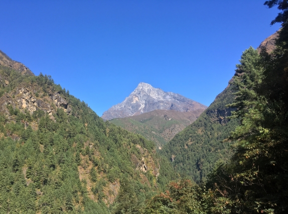
At the top of the hill was the first viewpoint of Mt Everest—its icy peak framed by pine trees with a backdrop of a clear blue sky. What. A. Reward. The Goddess was peering over Nuptse Ridge and seemingly welcoming her guests after that punishing climb to Namche Hill. AS much as I wanted to indulge myself in her beauty, Jangbu had to get us going to walk 30-45 minutes more to Namche Bazaar.
The generally downhill terrain was a welcome respite after our ascent. We, still with the Norwegian couple, reached our teahouse called The Nest at around 3:40 in the afternoon after 3 hours of trekking, completing a distance of 7.45km.
Total trekking time today: 6 hrs and 13 mins
Total distance trekked: 17.10 km

First photo I took of Mt Everest after that punishing climb to Namche Hill. Such a beauty!
